
Though townships in Butler County, Kansas, began building stone arch culverts in earnest starting around 1890, occasional newspaper references still pop up periodically referring to the construction of stone culverts before this time. Stone culverts were far from common in Butler County before 1890, wooden culverts being decidedly the norm. Even when stone culverts were built in these early days, it is by no means clear how many of them were arch culverts versus slab culverts. However, newspapers hold clues to a well-built 1882 stone arch culvert, which in turn spanned the millrace of one of the earliest mills in the country, located near El Dorado.
The Burdett and Weeks Mill
According to the January 19, 1906, edition of The Butler County Democrat, which is where much of this story comes from, a mill was established on the banks of the Walnut River between 1870 and 1871 by A. M. Burdett, George Weeks, and B. L. Wheeler. Wheeler quickly retired from running the mill, and headed for Colorado, leaving Burdett and Weeks in charge of things. Apparently at some point, the mill was moved, coming to rest at the east end of what was, at the time, First Avenue, El Dorado. (Please note that the street-naming scheme of El Dorado appears to have changed since the time of the mill; what was formally First Avenue is now Locust Avenue.)
The mill received its power from the Walnut River, which was dammed near this point, and the mill was used to grind flour. It was a scenic place, often photographed. However, as time went on changes overtook the mill. One of the first was the addition of a steam engine to run the machinery, as the Walnut River proved to be too unreliable of a source of power. Ownership of the mill changed hands, and times grew hard as less and less wheat was being raised in Butler County. The mill was at last abandoned, and the machinery left in place while the whole building decayed. At last, in January of 1906, the mill burned down, the cause unknown for certain.
One notable feature of this story of the mill is the picture of the stone culvert shown in front of the mill in a picture periodically seen in the newspapers. Further information on this culvert reveals that it was one of the earliest in Butler County.
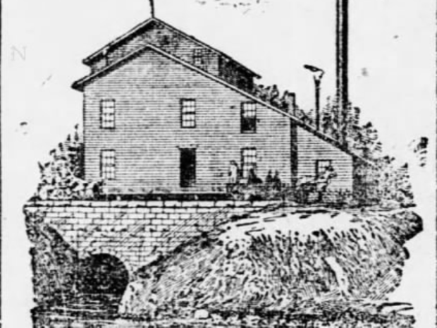
The June 30, 1882, edition of the Walnut Valley Times (weekly edition) reveals that $400 was appropriated by the county to build a stone culvert on the millrace of the Burnett and Weeks Mill. There can be little doubt that this culvert is the one shown at the old mill in the newspapers. Dating, then, from around 1882, this culvert was certainly one of the earliest stone arch culverts built in the county, even predating the beginning of the stone arch bridge and culvert building days of Butler County. The question is, what became of this early culvert?
What Became of the Culvert?
By 1906, the millrace was already filling. It is possible, even likely, that the millrace culvert disappeared under the sod. The question then becomes, where would the location of the culvert be? As it turns out, answering this question is not as easy as it may seem. The first complication is the changing of the street-naming scheme in El Dorado as mentioned above. However, using the county courthouse grounds as a reference point, it appears that First Avenue became Locust Avenue, First Avenue now being the name of a different road than the one the mill was located on. This established, a new complication arises: The Walnut River has moved!
The Walnut River splits into two branches at El Dorado. The mill was located less than a block south of the split. However, nowadays, this split occurs just north of Central Avenue/US 54, several blocks north of where the mill was. A look at the shape of the river now as compared with how it is portrayed in the old maps shows that the river is decidedly different. One landmark in the old maps is Woodland Avenue, which was a short road that joined with First (Locust) Avenue on the east side of the river near the mill. Modern maps show a Woodland Avenue which joins with Locust, but the avenue is on the west side of the river. Has the river moved or been moved? Very likely. Is the modern Woodland Avenue a different one from the old Woodland Avenue? Possibly, yet, based on how much it appears that the river moved, it may very well be the same. In the final tally, the site of the old mill, and hence the culvert, is probably located now on the west side of the river, on or near Locust Avenue, at its easternmost extremity, the avenue no longer crossing the river. If the culvert still exists, it is almost certainly buried.
